
Tacheometry Basics in Surveying
What is Tacheometry?
Tacheometry (also called tachymetry or stadia surveying) is a rapid surveying method used in civil engineering to determine horizontal distances, elevations, and relative positions of points on the Earth's surface without direct chaining or taping.
It relies on angular observations using a tacheometer (a theodolite fitted with stadia hairs) and a graduated staff (stadia rod or leveling staff) held at the target point. This makes it ideal for:
- Topographic mapping over large or rough areas
- Reconnaissance surveys for highways, railways, dams, etc.
- Areas with obstacles where direct measurement is difficult
- Quick collection of data for contouring and profiles

Basic tacheometry setup showing instrument sighting to a staff
Principle of Tacheometry (Stadia Method)
The most common method is the stadia method (fixed hair method), based on similar triangles and optics. The telescope has extra horizontal stadia hairs (upper and lower) in addition to the central cross-hair.
When viewing a vertical staff through the telescope, the apparent intercept (difference between upper and lower stadia hair readings) is read as s (staff intercept).
Key constants (usually marked on the instrument):
- K (multiplying constant or stadia interval factor) = f/i ≈ 100 (f = focal length, i = distance between stadia hairs)
- C (additive constant) = f + c ≈ 0 (with anallactic lens in modern instruments)
Basic Formulas
Case 1: Horizontal line of sight, vertical staffHorizontal distance D = K × s + C
(Usually simplified to D = 100s when C = 0)
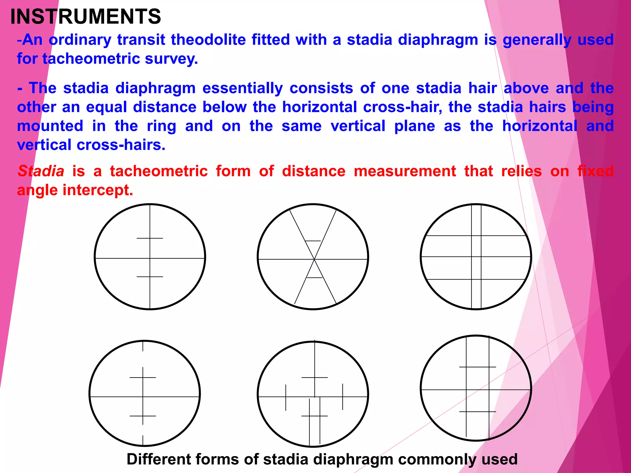
Different stadia diaphragm cross-hair patterns used in tacheometers
Let θ = vertical angle (angle of elevation or depression to the central hair)
Horizontal distance: D = (K s + C) cos²θ
(or more precisely: D = K s cos²θ + C cosθ)
Vertical distance (difference in elevation component): V = (K s + C) sinθ cosθ
(or: V = ½ K s sin 2θ + C sinθ)
Reduction to horizontal: D = K s cos²θ + C cosθ
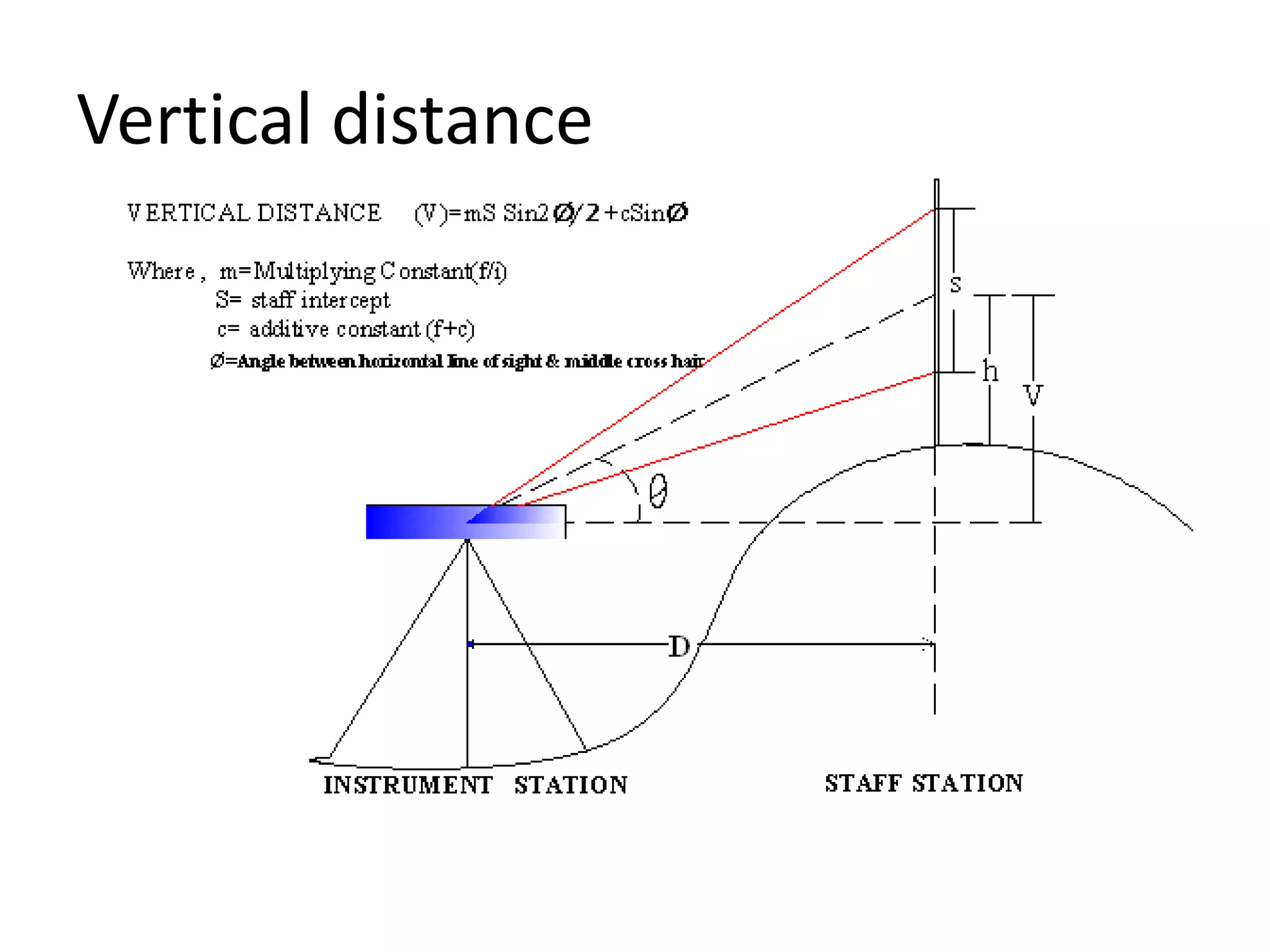
Diagram showing vertical distance (V) and staff intercept (s) for inclined sight

Explanation of tacheometric constants (K & C) in stadia method
Advantages and Limitations
Advantages:- Fast and efficient for large areas
- No need for chaining/taping
- Both horizontal & vertical data collected simultaneously
- Useful in rough/hilly terrain or obstructed sites
- Lower accuracy than modern total stations or GPS (typically 1:500 to 1:1000)
- Errors from refraction, staff not vertical, or poor visibility
- Less precise for long distances (>150–200 m)
Modern Context
While traditional tacheometry (optical stadia) is still taught for fundamentals, most field work today uses electronic total stations or EDM + theodolite for higher precision. However, understanding stadia basics remains essential for surveying students and engineers working in resource-limited settings.
Want to learn more? Check related videos or textbooks on tacheometric surveying!


0 Comments