
Underground surveying technique :
Underground surveying is a branch of surveying that deals with the measurement and mapping of features beneath the Earth's surface. It involves the use of specialized techniques and equipment to gather data about subsurface conditions and create accurate maps of underground spaces. Here are some key aspects of underground surveying:
1. Purpose: Underground surveying is performed for various purposes, including:
- Planning and designing underground infrastructure such as tunnels, mines, and utility systems.
- Mapping geological features, such as rock formations, faults, and groundwater resources.
- Assessing the stability and safety of underground structures.
- Locating and mapping underground utilities, such as pipelines and cables.
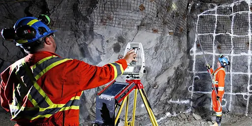
2. Techniques: Several techniques are employed in underground surveying, depending on the specific requirements and conditions. These techniques may include:
- Terrestrial surveying methods: Traditional surveying methods, such as using total stations and theodolites, can be adapted for underground surveys by setting up survey control points at known locations within the underground space.
- Laser scanning: 3D laser scanning technologies, such as LiDAR (Light Detection and Ranging), can be used to capture highly detailed point cloud data of underground spaces.
- Ground penetrating radar (GPR): GPR uses radar pulses to create subsurface images, allowing surveyors to identify underground features and structures.
- Sonar: Sonar systems use sound waves to map underwater or submerged underground spaces, such as flooded tunnels or underground lakes.
3. Challenges: Underground surveying presents several challenges compared to surface surveying due to limited access, low visibility, and complex geological conditions. Some of these challenges include:
- Limited access: Surveyors often have to work in confined spaces with restricted entry points, making data collection and equipment setup more difficult.
- Poor visibility: Underground spaces are often poorly lit or completely dark, requiring the use of specialized lighting and imaging technologies.
- Geological conditions: Underground environments can be unstable, with the presence of loose rocks, water, and other hazards, necessitating safety precautions during surveys.
4. Data interpretation and analysis: Once the survey data is collected, it needs to be processed, interpreted, and analyzed to create accurate maps and models of the underground space. This may involve using specialized software for point cloud processing, data fusion, and generating 3D representations of the surveyed area.
Underground surveying plays a crucial role in various industries, such as civil engineering, mining, geology, and environmental assessment. It helps ensure the safe and efficient construction and operation of underground infrastructure while providing valuable information about subsurface conditions.


0 Comments